- Thermal imaging goes mainstream: Once limited to the military, thermal “heat vision” devices are now available to consumers in many forms – from pocket phone cameras to drone systems – with a red-hot global market growing as prices drop ts2.tech digitalcameraworld.com.
- Wide range of devices: Key categories include handheld monoculars and binoculars, rifle-mounted scopes, smartphone attachments, and thermal camera drones, each tailored to different users (hunters, homeowners, first responders, etc.) ts2.tech.
- Civilian vs. military: Civilian thermal viewers average around $3,000 and span budget gadgets under $400 to elite gear over $7,000 outdoorlife.com outdoorlife.com. Militaries employ even more advanced (often cooled) thermal optics and fused night vision goggles for long-range, all-condition vision ts2.tech ts2.tech.
- Performance factors: Resolution ranges from ~160×120 in phone cams to 640×480 or even 1280×1024 in high-end units, enabling detection of human targets from a few hundred meters up to ~2.8 km with top-tier lenses ts2.tech shotshow.org. Battery life varies widely – some smart scopes run 16+ hours on a charge amazon.com, while clip-on phone cams last ~1.5 hours ts2.tech. Most devices are ruggedized for outdoor use (water-resistant, shockproof) ts2.tech.
- Expert insights: Industry voices note that the best thermal camera is “the one you have with you,” underscoring the trend of integrating thermal sensors into everyday gear like smartphones ts2.tech. Reviewers report modern thermal optics can reveal incredible detail – “I could easily identify steel targets at 800 yards, and deer at 150 yards had sharp detail,” said one field tester of a 640-class monocular outdoorlife.com.
- New trends: AI-powered thermal imaging is on the rise, enabling automatic target recognition, enhanced image clarity (super-resolution), and real-time alerts prnewswire.com ts2.tech. Multi-spectral fusion of thermal with visible or low-light cameras is increasingly common, giving a richer, layered view of the scene visidon.fi. Meanwhile, ongoing miniaturization of sensors is leading to compact, lower-cost devices – even under $200 – without sacrificing performance prnewswire.com ts2.tech.
- Global market dynamics: North America and Europe lead in defense and automotive thermal applications, but China now produces over 60% of thermal sensors and is driving consumer/industrial growth optics.org optics.org. Export laws restrict military-grade thermal gear – carrying a thermal scope across borders may require special permission pulsarvision.com. In many countries (e.g. parts of Europe), weapon-mounted thermal sights face legal limits for hunting, whereas handheld thermal viewers are generally allowed thestalkingdirectory.co.uk.
Introduction
Thermal imaging devices – which translate invisible heat radiation into visible images – have burst out of niche military use into the mainstream in 2025 ts2.tech. This technology lets you “see” in total darkness, smoke, or fog by detecting temperature differences, a capability invaluable for finding people or animals at night, spotting electrical hotspots, and more ts2.tech. The global thermal vision market is “red hot” and expanding rapidly as more brands jump in and prices gradually fall (though high-end gear still commands a premium) ts2.tech. Once users experience this “Predator vision,” many say it’s hard to go back ts2.tech.
In this report, we compare the latest thermal vision devices across all major categories – from handheld monoculars and binoculars to weapon-mounted scopes, smartphone-based cameras, and drone-mounted sensors ts2.tech. We’ll examine their features, performance, pricing, and uses, highlighting both civilian-friendly gadgets and military-grade systems. We also dive into emerging innovations like AI enhancements, compact sensors, and multispectral fusion, and discuss how regional markets and regulations influence what’s available to consumers. Whether you’re a hunter, homeowner, first responder, or tech enthusiast, this guide will illuminate the state of thermal imaging tech in 2025 – where seeing the unseen is easier than ever.
Thermal Monoculars (Handheld)
Thermal monoculars are single-eyepiece viewers designed for scanning environments and spotting heat signatures on the go. Because they’re not weapon-mounted, they’re extremely versatile – useful for wildlife observation, search-and-rescue, home security, or just finding where the heat is leaking in your house outdoorlife.com. Monoculars tend to be small and lightweight, fitting in one hand. This compact design is a big plus for hikers and hunters traveling light darknightoutdoors.com. They also often last longer on a charge than bulkier dual-eye devices darknightoutdoors.com. Another unique advantage: using a monocular lets you keep one eye dark-adapted. Only one eye faces the bright screen, so your other eye retains its natural night vision – a benefit for night hunters who want to avoid “night blindness” when they look away from the device darknightoutdoors.com.
Performance & Features: Modern monoculars come with a range of sensor resolutions and lens options. Budget units under $500 might have a 160×120 pixel sensor (good enough to detect a human at a few dozen yards as a warm blob). Premium models use 320×240 or 640×480 sensors for much sharper thermal images. The very best now even feature 1024×768 or 1280×1024 sensors, delivering unprecedented detail. For example, Nocpix (InfiRay Outdoor’s new brand) offers the Vista series – their top model packs a 1280×1040 detector for ultra-crisp imaging (at a price around $5,200) outdoorlife.com. More commonly, a 640×512 sensor is considered high-end, and in testing such 640-class viewers can resolve impressive detail – testers reported seeing the musculature of animals at 400 yards, whereas cheap units only showed indistinct “hot blobs” outdoorlife.com. Detection range depends on sensor and optics: a mid-range 320×240 monocular might detect a human out to a few hundred meters, while a high-end 640 device with a large lens can spot human heat at 800+ yards in ideal conditions outdoorlife.com. FLIR’s new Scout Pro (a law-enforcement oriented monocular) has a wide 32° field of view and can detect human heat signatures up to 500 meters away firerescue1.com.
Despite their small form, many monoculars now boast features once reserved for bigger devices. It’s common to find on-board recording, Wi-Fi streaming to a phone app, multiple color palettes, and even integrated laser rangefinders in higher-end units. For instance, the Pulsar Axion 2 XQ35 Pro LRF includes a laser rangefinder for precise distance reading, and the Nocpix Vista H50R we mentioned not only ranges targets out to 1,200 yards but can wirelessly transmit that range data to a paired thermal scope via a system called N-Link outdoorlife.com. This essentially lets a spotter with the monocular feed distance info directly to a shooter’s scope – a tactic that spotter-shooter teams love for nighttime hunting.
Use Cases: Because they aren’t tied to a rifle, monoculars are used for everything from scouting game and navigating in darkness to finding a downed deer in the brush by its heat. Hikers and campers use them for wildlife watching at night. Farmers use them to check on livestock or detect predators near the barn. And in home or industrial settings, a handheld thermal is great for diagnosing insulation gaps, electrical hotspots, or water leaks (although dedicated “thermal cameras” with accurate temperature readings are often used for trade work). Monoculars cover a wide price spectrum – “there’s a thermal viewer for every use case and budget,” as one field review noted outdoorlife.com outdoorlife.com. Entry-level units like the Topdon TC004 can be had for under $400, while flagship models like the military-grade Trijicon REAP-IR or the latest 1280-resolution devices can run $5,000–$7,000+. The average price for a quality monocular hovers around $3,000 outdoorlife.com, with performance generally scaling with cost.
Military-Grade Monoculars: Many militaries issue thermal monoculars or bi-oculars to soldiers for enhanced vision at night. A well-known example is the FLIR Breach PTQ136, an ultra-compact 320×256 monocular that can clip onto helmets – it’s used by law enforcement and special forces to spot suspects in total darkness firerescue1.com. For infantry, there are also fused solutions: the U.S. Army’s new ENVG-B goggles combine a normal image-intensifier night vision tube with a thermal imager in a binocular helmet-mounted display ts2.tech. This gives soldiers the best of both worlds – the ability to see fine detail and light sources via traditional night vision plus the ability to see warm targets through smoke or camouflage via thermal. Such systems even support wireless linking to weapon sights for rapid target acquisition ts2.tech. Military thermal viewers often use cooled thermal sensors for longer range and higher sensitivity. These cooled units (cryogenically chilled mid-wave IR cameras) can detect human activity several kilometers away and discern smaller temperature differences than uncooled civilian units – but they are larger, heavier, and astronomically expensive. For example, a cooled handheld imager for long-range surveillance can cost tens of thousands of dollars, well outside the civilian market. In general, the gap between civilian and military handheld thermals is narrowing as uncooled sensor tech improves. Today’s uncooled 640+ resolution monoculars with <40 mK sensitivity approach the performance needed for many tactical scenarios without the logistical burden of cooled systems prnewswire.com.
User Friendliness: Most thermal monoculars are designed to be intuitive, with simple button menus and diopter focus adjustments. Many users find monoculars easy to carry and operate one-handed. One downside is the potential for eye fatigue – squinting one eye through a scope for long periods can tire you out. However, as noted, using one eye can be advantageous to preserve night vision in the other. Some models include features like adjustable screen brightness or red color modes to reduce eye strain and prevent vision flash. Overall, for a balance of portability and utility, it’s hard to beat a good thermal monocular as your all-purpose “thermal vision” tool.
Thermal Binoculars (Dual-Eye)
Thermal binoculars (and bi-oculars) provide a two-eyed viewing experience, which has its own pros and cons. These devices have two eyepieces (and either one or two thermal sensors) so that you can look with both eyes, much like conventional binoculars. The big advantage is comfort and depth perception: using two eyes is more natural for our brains, reducing eye strain and improving viewing comfort during long observation sessions darknightoutdoors.com. Many users find they can scan longer with thermal binos without fatigue or headaches, compared to squinting through a monocular. In high-stakes situations – search & rescue or security surveillance – this comfort can be a significant benefit.
Because of their larger form factor, binocular units often pack top-tier capabilities. Expect larger objective lenses (for greater detection range), higher resolution sensors, and often a suite of extra features. For example, the AGM Global Vision ObservIR 60-1280 is a high-end thermal binocular that our research turned up as “Best Thermal Binocular” in one 2025 field test outdoorlife.com. It features a whopping 1280×1024 thermal sensor, delivering class-leading image quality, paired with a 60mm germanium lens. This model also integrates a laser rangefinder (effective to 1,000 meters) and even includes a secondary low-light digital day/night camera with an 850 nm IR illuminator for times when you might want a standard night vision view outdoorlife.com. In fact, many modern thermal binoculars are dual-spectrum: they fuse a thermal channel with a daylight or starlight camera. Pulsar’s Merger Duo binoculars, for instance, combine a thermal imaging sensor with a low-light CMOS sensor, allowing you to overlay or switch between thermal and traditional night vision for more detail. The ObservIR similarly offers a “fusion” view – it’s described as a “dual-spectrum thermal and digital day/night system,” giving the user both a heat picture and a conventional image for context outdoorlife.com. This multi-sensor approach is a trend in high-end optics to mitigate thermal’s weakness (lack of detail/edges) by adding outlines or color from a normal camera visidon.fi.
Trade-offs: The obvious downsides of binoculars are size, weight, and cost. Having two eyepieces (and sometimes dual sensors/displays) makes them bulkier. They usually require using both hands, unlike a small monocular you can quickly raise with one hand. Battery life can also be shorter; driving two displays (one per eye) and extra sensors drains more power – some thermal binos won’t run as long as an equivalent monocular darknightoutdoors.com. Many binocular units have swappable or rechargeable battery packs and often advertise around 6–8 hours of operation per charge for continuous use outdoorlife.com. For instance, the ObservIR has about an 8-hour runtime on a single charge outdoorlife.com, which is quite good, and it uses an external battery pack system so you can hot-swap if needed.
The expense is significant: designing precision dual-eye optics with aligned thermal images is complex, and production volumes are low. It’s not uncommon for thermal binoculars to cost $5,000 to $10,000 or more. The AGM ObservIR in our example retails around $7,495 outdoorlife.com. Pulsar’s Merger models and military-grade binos can also fall in that price range or higher. If price is a primary concern, monoculars (which are simpler devices) are generally much more affordable for comparable specs darknightoutdoors.com darknightoutdoors.com. For instance, a 640×480 monocular might be $3k while a 640×480 binocular (if one exists) could be double that. There are a few “budget” thermal binoculars, but they often actually house a single sensor that feeds both eyes (sometimes called bi-oculars) – giving you two eyepieces but one thermal core – which saves cost. An example is the older ATN Binox series which provided dual-eye viewing from a single 320×240 sensor. These can be found in the $1,500–$3,000 range, but they are less common in 2025 as most people either go monocular or splurge for true binocular.
Performance: Thanks to large optics and high-res cores, the detection range on thermal binoculars can be superb. Many can spot vehicle-sized heat sources from several kilometers away and human-sized targets well beyond a mile under the right conditions. One of Pulsar’s flagship binoculars advertised detecting a human heat signature at over 2000 meters. With the advent of 1280×1024 uncooled sensors (like in the ObservIR or Pulsar Merger XL50), the clarity at long range is greatly improved – you’re not just detecting a far blob, but can often distinguish some details. As a concrete example, Pulsar claims its latest 1024×768 scope (Thermion XL60) can detect a 1.8m object at 2,800 m shotshow.org; a binocular using a similar sensor and lens would be in that ballpark as well. In practice, atmospheric conditions (humidity, temperature differences) limit long-range thermal performance, but it’s safe to say a top binocular will far outreach typical hand-helds or scopes in detection range.
Use Cases: Thermal binoculars shine for applications that involve prolonged viewing and scanning. Police and border security units use them for surveillance, since an officer can comfortably surveil an area for extended periods. Search and rescue teams like binoculars for scanning large areas (e.g. a mountainside at night for a missing person) – the dual-eye view and often wider objective lens help pick up faint heat traces. Wildlife observers and researchers also appreciate the comfort; for instance, watching animal behavior at night from a distance is easier with binocular vision. Hunters sometimes use binoculars for scouting from a fixed position (though many hunters opt for a monocular for mobility). On the marine side, thermal binoculars are used on boats and ships to spot obstacles or persons overboard in darkness; these are usually ruggedized and sometimes stabilized models.
Ruggedness: Given their professional audience, most thermal binoculars are built extremely tough – waterproof, dustproof, and able to handle extremes of temperature. Many are rated IP67 or better (meaning they can be submerged briefly and still work). They often have reinforced housings to protect the expensive optics inside.
In summary, thermal binoculars represent the high end of handheld thermal vision. They offer the best image quality and comfort, at the cost of higher weight and price. As one optics expert put it, using two eyes for thermal is more “intuitive and ergonomic”, alleviating eye strain and giving a natural viewing experience darknightoutdoors.com. But for many users, the added bulk and expense mean binoculars are only justified if your application truly needs that extended, comfortable viewing – otherwise a monocular or scope might suffice. For those who do invest in them, thermal binoculars can be an unrivaled tool for observing the night in rich detail.
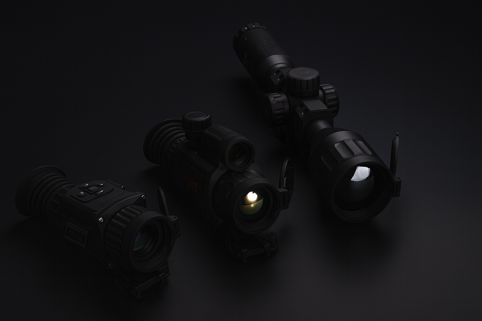
Thermal Rifle Scopes
Thermal rifle scopes marry infrared imaging with a weapon sight, allowing shooters to aim using heat signatures. These have become extremely popular for night hunting (predator and hog control) and see heavy use in the military for target engagement in low-visibility conditions. A thermal scope replaces or clips onto your normal scope, displaying a thermal image with a reticle (crosshair) to put on target. In 2025, thermal scopes range from surprisingly affordable entry models to cutting-edge smart optics that border on sci-fi.
Key Features: A thermal scope must withstand the recoil of firearms, so they’re built with rugged housings (often aluminum) and recoil-rated internals. They typically have magnification options (either optical and digital zoom or purely digital zoom on a fixed lens). Current civilian scopes often use sensors of 384×288 or 640×480 resolution, though top-tier units now sport higher resolutions (Pulsar, for example, introduced Thermion 2 LRF XG60 and XL60 models – with the XL60 using an ultra-fine 12 µm 1024×768 sensor ts2.tech). Higher resolution yields a clearer image and better identification at range, especially important for safe shooting (to identify species or to tell if an animal is standing in front of brush vs. a person, etc.).
One of the most powerful scopes this year is the Pulsar Thermion 2 LRF XL60, which features a 1024×768 sensor and a 60mm objective. It can detect human-sized targets out to about 2,800 meters in ideal conditions – nearly 1.75 miles ts2.tech. This model also integrates a laser rangefinder and a crisp 2560×2560 AMOLED display for the shooter shotshow.org. However, such performance isn’t cheap: these high-end Thermions run in the $5,000–$9,000 range depending on configuration ts2.tech. They represent the upper echelon of civilian scopes, approaching military grade.
Fortunately, thermal scopes have also plummeted in price at the entry level. You can find basic 240×180 or 256×192 resolution scopes for around $1,000–$1,500 now. A very common class is the 384×288 uncooled scope, many of which are now under $2,000 ts2.tech. Brands like ATN, AGM, and Bearing Optics offer mid-resolution scopes at prices that even a hobbyist hunter can consider. These typically have 25 or 35mm lenses, giving detection ranges around 500 yards for human-size targets (identification at maybe 200 yards). They might not have the prettiest image or longest reach, but they do the job for moderate-range pest control.
Smart Scope Capabilities: Many thermal scopes today are “smart” scopes, meaning they include advanced electronics for recording video, connecting to smartphones, and even aiding your shot. For example, ATN’s popular ThOR 4 series functions like a scope-shaped computer: it records HD video of your shots, streams to an app, has a ballistic calculator, and can even display a ballistically corrected reticle if you input your ammo’s profile. Remarkably, the ThOR 4 also boasts an internal battery lasting 16+ hours amazon.com, eliminating the need for carrying spares on an all-night hunt. This long battery life is an industry leader – many other scopes run 4–8 hours on a charge, or use CR123 batteries that you swap every couple hours. ATN achieved this by an efficient dual-core processor and power management system amazon.com.
Other scopes integrate features like recoil-activated video (so they automatically capture the few seconds around your shot), Wi-Fi/Bluetooth for syncing or even live-streaming the thermal view, and multiple color palettes/reticle options. Some include picture-in-picture zoom views to help in aiming without losing wide context. Laser rangefinders are increasingly built-in or available as attachments – knowing the exact distance to target helps when using thermal because depth perception can be poor in a flat thermal image. The Pulsar Thermion 2 LRF models, as the name suggests, have a laser rangefinder integrated, and they can even pair with a smartphone app to display or log coordinates and shots ts2.tech.
Military and High-End: The military has a long history with thermal weapon sights. Notably, the US Army’s Family of Weapon Sights – Individual (FWS-I) is a recent program delivering advanced uncooled thermal sights for soldiers. These are 60 Hz refresh rate, 640×480 resolution scopes with multiple zoom levels and reticles, designed to mount on rifles ts2.tech. One cool aspect: the FWS-I can wirelessly transmit its sight picture to the soldier’s ENVG-B goggles, so a soldier can aim their rifle without looking through the scope – they see the thermal scope’s view in their helmet display ts2.tech. This “Rapid Target Acquisition” tech is a game-changer in close quarters and demonstrates how far integration is going. Military scopes also can incorporate sensor fusion, combining a day optic or a low-light channel with thermal. While not yet standard issue, prototypes exist (some Israeli firms have showcased scopes that merge an optical day scope with a thermal overlay) ts2.tech. Cost and complexity keep those mostly experimental for now.
Cooled thermal scopes are used on some military sniper rifles and vehicle-mounted heavy weapons. These mid-wave IR sights can have extremely long range and higher resolution (sometimes 1280×1024 or more), but again require cooling engines and are not man-portable in the same way (think of tank sights or TOW missile thermal sights).
Emerging Trends in Scopes: We’re on the cusp of truly “smart” scopes that do more of the work for the shooter. One trend is automated fire control – a scope that not only ranges a target but also adjusts the aiming point or highlights targets. The idea of a digital scope that shows a range-adjusted aimpoint (accounting for bullet drop) is already implemented in some civilian products (Sig Sauer’s BDX system, for example, albeit with day optics). In thermal, we see preliminary steps: some ATN scopes will shift the reticle once you range a target if you’ve entered ballistic data. More advanced is the Army’s new ENVG-B+FWS-I combo which essentially lets you shoot around corners using the wireless link. As another example, the smart scope on the new U.S. Army NGSW (Next-Gen Squad Weapon) program – Vortex’s XM157 – is a day optic but it shows how scopes are becoming digital multi-sensors (with rangefinder, computer, and possibly thermal overlay in future versions).
By 2026–2027, analysts predict thermal scopes will incorporate AI features – imagine a scope that can automatically recognize a human vs. animal shape and perhaps outline or tag it on your display ts2.tech. Teledyne FLIR has been creating huge thermal image datasets to train AI for object recognition, meaning future thermal sights will be much “smarter” about interpreting what you’re aiming at ts2.tech. Early steps of this are seen in some hunting scopes that offer an “animal highlight” mode (using simple pixel thresholding to highlight the hottest spots) and in experimental military scopes that might outline targets.
Another trend is clip-on thermal imagers that attach in front of traditional scopes. At the 2025 SHOT Show, multiple companies showed small clip-on thermal sights that turn a regular day scope into a thermal scope without re-zeroing ts2.tech. For instance, AGM’s Victrix and Steiner’s Cinder are clip-on devices you mount on your rifle’s forward rail; they project a thermal image into your regular scope’s view ts2.tech. The advantage is you can still use your familiar day scope (with its exact reticle and zero) and just add thermal capability on demand. Clip-ons tend to be expensive, but they’re popular with those who have high-end glass optics already. There are also micro thermal sights being developed for niche uses – one company, InfiRay, even showcased a pistol-sized thermal sight (Fast FMP13), illustrating how miniaturized the tech is getting ts2.tech.
Usage: In the civilian world, thermal scopes are primarily used for night hunting of feral hogs, coyotes, and other nuisance predators (where legal). In states like Texas, hunting wild hogs at night with thermal optics has almost become mainstream, with a whole community of hunters and outfitters specializing in it ts2.tech. Thermal scopes allow detection and engagement of animals that are entirely invisible to the naked eye. They’re also used for invasive species control (e.g. shooting nutria or rats at night) and by some tactical shooters for sport (nighttime 3-gun competitions sometimes allow thermal optics). Law enforcement SWAT teams might employ a thermal scope for a sniper overwatch at night, though typically they use image intensifiers unless total darkness or obscurants make thermal necessary.
One must note that in many jurisdictions, use of thermal scopes for hunting game animals (like deer) is restricted for ethical and fair-chase reasons thestalkingdirectory.co.uk. Hunters should always check local laws – some places only allow thermal/night vision for certain species (like feral hogs or varmint pests) or require special permits. Using a thermal weapon sight is considered such an advantage that it’s tightly regulated for game animals in regions of Europe and parts of the U.S. thestalkingdirectory.co.uk thestalkingdirectory.co.uk.
Conclusion (Scopes): Thermal rifle scopes in 2025 offer an incredible capability: the power to aim accurately in complete darkness. They have become more accessible to civilians in recent years, with mid-range models priced similarly to premium conventional optics. At the top end, they are incorporating advanced tech (LRFs, video, apps) that make hunting and shooting more effective and fun. The military continues to push the envelope, working on integrated systems and higher-performance sensors, many of which eventually filter down to civilian tech. For anyone needing to shoot at night – whether farmers culling predators or soldiers on patrol – thermal scopes are an invaluable tool, essentially providing true 24/7 all-weather targeting. As one expert succinctly put it, the thermal scope is “no longer sci-fi – it’s on the cusp of reality” for even squad-level use ts2.tech, and on the civilian side it’s already a reality you can buy off the shelf.
Smartphone Thermal Cameras & Attachments
One of the most exciting developments in thermal imaging is how it’s been shrinking and integrating with consumer electronics. You no longer need a specialized standalone device to get thermal vision – you can use your smartphone. There are two approaches: attachment cameras that plug into a phone or work wirelessly with it, and smartphones with built-in thermal imaging modules. Both have opened up thermal imaging to hobbyists, DIYers, and professionals who wouldn’t have invested in a bulky $3000 imager but are happy to spend a few hundred to add capability to their phone.
Clip-on & Wireless Attachments: The big name in this space is FLIR (Teledyne FLIR), which pioneered consumer thermal phone cameras with its FLIR One series. The latest iteration is the FLIR One Edge Pro, a wireless thermal camera that clips onto any iOS or Android device (or can even be used handheld off-phone via Bluetooth/WiFi) ts2.tech. It features a 160×120 resolution Lepton sensor and uses FLIR’s MSX image blending (overlaying faint visible edges on the thermal image for clarity) ts2.tech. Reviewers have praised the One Edge Pro’s convenience for homeowners and contractors – it’s great for checking insulation, finding water leaks or electrical hotspots, etc. ts2.tech. The device streams thermal imagery to the FLIR app on your phone, where you can capture photos/videos and even get spot temperature readings. The trade-offs: its small battery lasts about 1.5 hours of use and it costs about $500 (mid-2025 pricing) ts2.tech ts2.tech. Still, for a rugged, pocket-sized thermal imager that essentially gives your phone “Predator vision,” it’s a top choice.
Another well-known player is Seek Thermal. Seek offers plugins like the Seek Compact and Seek CompactPRO, and recently launched the Seek Nano series as next-gen smartphone attachments. The Seek Nano 300 model provides a 320×240 thermal sensor – the highest in this class – with a 25 Hz frame rate, for about $519 thermal.com. There’s also a Nano 200 (200×150 res at 25 Hz) for $214, making true thermal imaging very affordable thermal.com thermal.com. These attach via the charging port (Lightning or USB-C). Seek emphasizes they achieved “the highest image quality available for smartphone thermal cameras at a market-leading price” thermal.com. Indeed, a 320×240 sensor in a $500 phone accessory would have been unthinkable just a couple years ago. Most earlier phone cams were 80×60 or 160×120 resolution due to cost and export limitations. Seek and others overcame some of those barriers (leveraging higher frame rates and res while complying with export laws by limiting certain specs if needed).
New startups are entering the space too. In early 2025, a Vietnam-based startup HSFTOOLS announced the Finder S2, a plug-in USB-C thermal dongle with a 256×192 sensor that uses on-board algorithms to upscale images to 960×720 for extra detail ts2.tech ts2.tech. Impressively, it has ≤40 mK sensitivity (comparable to larger cameras) and can measure temps from -20°C to 400°C ts2.tech. The company’s marketing director, Jule Yue, said “Our goal…was to break down the barriers to thermal imaging, making it accessible to everyone,” highlighting that at an expected price under $400, the Finder S2 puts pro-grade thermal power in anyone’s hands ts2.tech ts2.tech. This kind of sentiment and pricing shows how competitive the smartphone attachment market is becoming.
All these attachments generally feed into an app on your phone that provides extra functionality: palette selection, temperature readouts, image blending, and sharing of thermal images. Some apps even do analysis like highlighting the hottest point in the image automatically ts2.tech. The convenience factor is huge – as one industry expert quipped, “The best thermal camera is the one you have with you,” underscoring why having a thermal imager in your pocket (via your phone) is a game-changer ts2.tech. No need to carry a separate device and charged batteries; just grab the little adapter when needed.
Integrated Thermal Smartphones: Parallel to attachments, a number of rugged smartphones with built-in thermal cameras have hit the market. Caterpillar was an early pioneer with its Cat S60/S62 phones that had FLIR Lepton cores inside. In 2023–2025 we’ve seen brands like Sonim, Doogee, Oukitel, Blackview, and Ulefone release phones that come with thermal imaging built in. For example, Sonim XP8/XP10 (XP Pro Thermal) is a super-rugged Android phone that integrates a FLIR Lepton 3.5 sensor (160×120) and uses FLIR’s MSX overlay to combine thermal and visible images ts2.tech. Sonim’s Chief Commercial Officer touted that this all-in-one approach “eliminates the need for bulky standalone devices or costly add-ons” – now electricians, HVAC techs, or first responders can carry just a phone instead of a separate thermal imager ts2.tech ts2.tech. The Sonim XP8/XP10 thermal model packs a huge 5000 mAh battery as well, giving all-day thermal usage for field work ts2.tech.
On the Chinese side, Doogee launched the Fire 6 Max in 2025 – an Android phone with a massive 20,800 mAh battery (!) and a 120×160 resolution thermal module (upscaled to 240×240) ts2.tech ts2.tech. It’s marketed as a “thermal rugged phone” for outdoors, letting hikers spot wildlife or letting technicians inspect equipment on the go ts2.tech. Likewise, Ulefone released the Armor 28 Ultra (Thermal), which pushes the concept further by leveraging AI. It uses a “ThermoVue T2” thermal module with an AI algorithm that super-resolves images to effectively 640×512 with sharp detail ts2.tech. Ulefone claims the phone’s AI can sharpen thermal images by 17× and even do on-device object recognition, highlighting targets automatically ts2.tech. In fact, this phone has a high-end MediaTek processor with 16 GB RAM and dedicated AI chip, allowing it to run heavy computer vision tasks on the thermal feed in real time ts2.tech. The Armor 28 Ultra really underscores the trend of AI-powered thermal imaging on consumer devices – as Ulefone puts it, “AI computing introduced into thermal imaging leads to a qualitative leap in image detail,” enabling features like auto target highlighting and image fusion for richer visuals ts2.tech.
These thermal phones typically sit in the $600–$1000 price range – which, considering you get a full smartphone and a thermal camera, is quite attractive. They are almost always ruggedized (IP68 waterproof, drop-resistant) and cater to professionals who work in tough conditions (construction, inspections, wilderness, etc.). They often include other niche features like extra IR night-vision cameras (some Doogee and Blackview models also have a separate IR night vision camera with IR LED illuminators for non-thermal night pics) and huge batteries as mentioned. They are a growing niche of their own.
Capabilities and Limitations: Phone-based thermal cameras, whether attachments or integrated, do have limitations compared to standalone thermal optics. The sensors are typically smaller resolution and lens size, meaning detection range is limited. Expect to identify a human-size heat source at perhaps 20-50 meters with clarity for a 160×120 sensor (they appear as a small blob beyond that). You might detect a heat signature further, but distinguishing what it is gets hard. The frame rates are often limited to 8-9 Hz on models sold internationally (due to export rules on higher refresh thermal systems), though some newer ones (Seek Nano, Finder S2, certain phone models) are offering ~25 Hz in markets where allowed thermal.com ts2.tech. This is still below the 30/60 Hz of dedicated devices, so fast motion can appear a bit choppy.
Another limit is thermal sensitivity – phone add-ons have improved, some boasting 40 mK NETD, but they might struggle with subtle temperature differences compared to a professional imager. Also, because they lack a viewfinder, using them in bright daylight can be challenging (you have to look at your phone screen which may be hard to see in sun). They are mostly aimed at close-to-mid range observation and diagnostic tasks, not long-range spotting.
However, the upside is ease of use and sharing. With a phone thermal image, you can instantly send it, annotate it, or combine it with other data. The apps often allow creating reports (popular for home inspectors and electricians who need to document issues). As one tech writer noted, anyone can now access thermal imaging – whether to see wildlife in the dark or find where heat is leaking at home – thanks to these accessible phone-based solutions digitalcameraworld.com digitalcameraworld.com.
In summary, smartphone thermal attachments and thermal phones have truly democratized thermal vision. They exemplify the trend of portability and integration: a theme where thermal tech is no longer a specialist’s tool but a common gadget ts2.tech ts2.tech. As we head into 2026, rumors hint at even higher-resolution phone thermal sensors (perhaps leveraging the new 6 µm pixel sensors) and more devices incorporating thermal cameras ts2.tech. We may soon see mainstream phone brands jump in, or at least an expansion of models from the current players. The bottom line is that if you want thermal vision on a budget, you no longer have to dream – you can add it to your phone and join the thermal revolution.
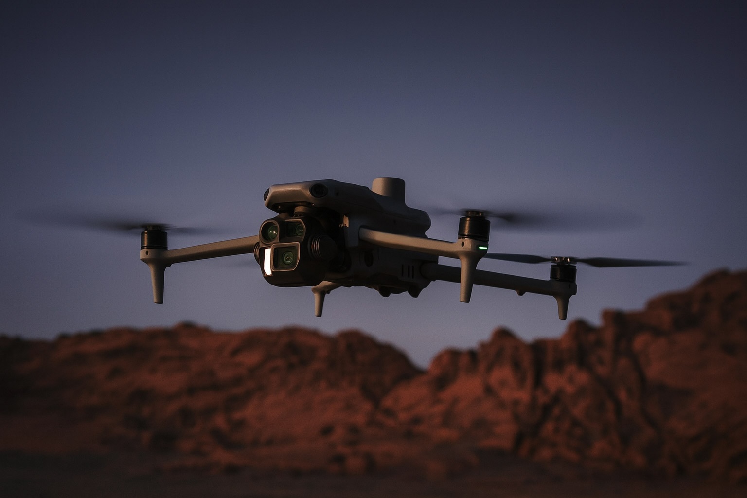
Thermal Imaging Drones
Putting a thermal camera on a drone adds a whole new dimension to surveillance and imaging – literally elevating it. Thermal drones (unmanned aerial vehicles equipped with infrared cameras) have become indispensable in fields like emergency response, law enforcement, industrial inspection, and wildlife management. By combining mobility with thermal vision, drones can cover large or hard-to-reach areas quickly, providing a heat-map view from above heliguy.com heliguy.com.
Civilian/Enterprise Thermal Drones
In the civilian and commercial realm, the leading drone manufacturers have all introduced models or payloads with thermal cameras. DJI, the dominant drone maker, offers several options:
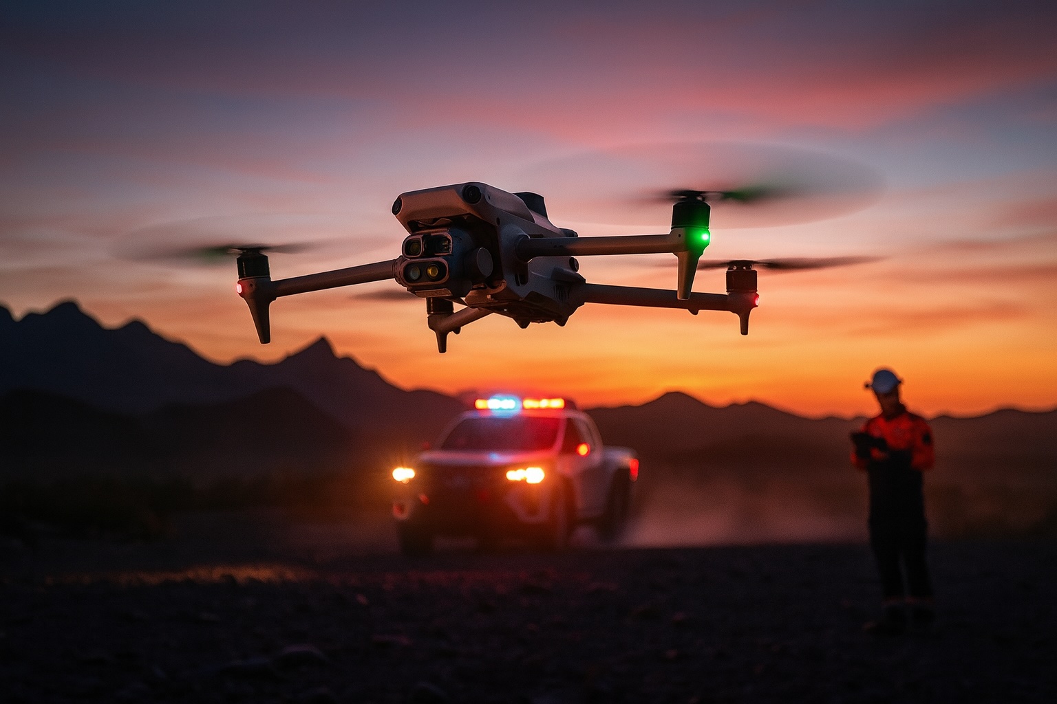
- The DJI Mavic 3 Thermal (Mavic 3T) is a compact, foldable drone (~920 g) designed for portability heliguy.com heliguy.com. It features a triple-camera system: a 48 MP visible wide camera, a 12 MP telephoto with up to 56× hybrid zoom, and a 640×512 resolution thermal sensor heliguy.com. This allows not only thermal imaging but also visual inspection and the ability to zoom in for details. The M3T can even do split-screen views comparing thermal and RGB side by side heliguy.com. With up to 45 minutes flight time per battery heliguy.com and easy deployment, it’s ideal for quick-response missions like finding a missing person in the woods at night or scanning a solar farm for faulty panels. It’s essentially a flying thermal binocular, but with the advantage of being able to cover ground rapidly.
- The DJI Matrice 30T (M30T) represents a larger, rugged enterprise drone for heavy-duty use. It carries an integrated payload that includes a 640×512 thermal camera, a 12 MP wide camera, a 48 MP zoom camera, and even a laser rangefinder (out to 1200 m) heliguy.com heliguy.com. The M30T is IP55 rated, meaning it can fly in rain and dust, and operates in temperatures from -20°C to 50°C – crucial for firefighting and harsh environments heliguy.com. With ~40 minute flight time, the Matrice series drones are used by public safety agencies for search & rescue, by utilities for power line inspections (finding hot spots or failing components from the air), and by firefighters for spotting hidden hotspots in wildfires or buildings. Essentially, a drone like this can provide an overhead thermal view in real time, which is invaluable. For example, firefighters have used drones to detect unseen fire spread in a roof or to safely monitor chemical fires where approaching on foot is dangerous heliguy.com.
- DJI also makes standalone thermal camera payloads for drones, such as the Zenmuse H20T/H30T series. These can be mounted on high-end drones like the Matrice 300. The Zenmuse H30T, for instance, offers a 1280×1024 thermal resolution sensor (four times the pixels of a 640 sensor) with 32× digital zoom, alongside a 40 MP visual camera with up to 34× optical (and 400× digital) zoom, plus a laser rangefinder to 3000 m heliguy.com heliguy.com. This kind of sensor suite is cutting-edge – the thermal resolution is extremely high for a drone payload, enabling more detailed thermal imagery from altitude (useful for pinpointing small heat sources). Such a payload is geared towards demanding missions like power grid inspection (detecting overheating insulators or joints from a distance) or search and surveillance where identifying objects accurately is important. Of course, these are expensive systems (tens of thousands of dollars easily for the payload and drone).
Other manufacturers:
- Autel Robotics produces the Evo II Dual series and newer Evo Max series with thermal options (commonly a 640×512 sensor paired with an 8K or 4K camera). These are popular alternatives to DJI especially for users who want to avoid DJI (for government compliance reasons).
- Parrot had the Anafi Thermal and USA models with FLIR cores (320×256 resolution). Parrot’s solutions are smaller and aimed at quick deploy for public safety.
- Specialized industrial drones (e.g., for gas detection or high-end surveillance) often integrate FLIR Boson or Tau cores (thermal modules) depending on the need.
Use Cases: Thermal drones have demonstrated their worth in many scenarios:
- Search & Rescue: As noted in one case, police in North Wales found a missing person using a thermal drone faster than a helicopter could heliguy.com. The drone can see a warm body in a field or forest at night from an aerial view, which is often easier than from ground level. They’ve saved lives by finding hikers, Alzheimer’s patients, or accident victims quickly.
- Firefighting: Drones help detect hidden fire hotspots through smoke and visualize fire spread. For example, thermal drones were used in a warehouse fire in West Midlands to guide firefighters, improving safety by showing where the fire was hottest and where it had been extinguished heliguy.com.
- Law Enforcement: Police use thermal drones to track suspects at night (a person hiding in bushes lights up on thermal), to uncover illegal activities like clandestine drug grows (heat from indoor grow lamps can be spotted), and for overwatch in operations heliguy.com. They provide a silent, elevated thermal vantage point.
- Infrastructure Inspections: From pipelines to power lines to solar farms, thermal imaging can reveal leaks, electrical faults, or failing solar panels. Mounted on a drone, inspectors can survey long stretches quickly heliguy.com. For example, a drone can fly along power lines and the thermal camera will show if a transformer is running unusually hot (a sign of impending failure) or if a section of pipeline is cooler (potential leak of gas causing cooling).
- Agriculture: Thermal drones help in precision agriculture by identifying irrigation issues (dry vs. moist soil has different thermal signatures at certain times) or plant stress. They can also be used for wildlife spotting before harvesting (to avoid harming animals). Thermal provides different data than normal NDVI crop cameras, complementing farmers’ toolkits heliguy.com.
Military Drones: The military domain also heavily leverages thermal imaging on drones, from small quadcopters to large UAVs. Small tactical drones (like the Black Hornet or larger quadcopters) allow soldiers to peek around corners or over hills with thermal vision at night, enhancing situational awareness. Larger military drones (e.g., MQ-9 Reaper) carry advanced multi-sensor turrets that include cooled thermal cameras with extremely long range. Those systems can detect vehicles or people from many kilometers away and often have higher resolution and zoom than any civilian system (but they are classified and not for sale publicly). The military is also exploring drone swarms where some drones carry thermal, some visible, etc., working in concert to map battlefields day or night.
We’re also seeing interesting innovations like augmented reality (AR) displays for drivers using thermal feeds – one example: prototypes where a military vehicle driver has no window, but an AR windshield displays a fused visible/thermal panoramic view from cameras around the vehicle ts2.tech. This kind of tech is driven by the availability of compact thermal cameras that can be mounted on vehicles or drones feeding live imagery.
Purchasing and Availability: Thermal drones and thermal payloads are widely available on the commercial market, but advanced models can be pricey. A DJI Mavic 3T (thermal) kit might cost on the order of $5,000–$6,000. An enterprise Matrice 30T is significantly more. Nonetheless, even volunteer search-and-rescue teams and small fire departments are investing in these tools because they so clearly improve outcomes. From a regulatory perspective, flying drones at night usually requires special permissions or waivers (in some jurisdictions) but thermal cameras themselves are not restricted – except export-wise. Export laws classify thermal cameras above certain specs, so selling or shipping a high-end thermal drone across borders might need a license. DJI actually has different variants for different regions to comply (e.g., limiting frame rates to <9 Hz on some international versions to avoid export restrictions similar to handheld thermal devices).
The bottom line: Thermal imaging has taken to the skies, and it’s a perfect match. The bird’s-eye view combined with heat vision allows us to do things that were previously difficult or impossible, from saving lives in disasters to monitoring vast solar farms efficiently. As drone technology and thermal sensors continue to advance (lighter, higher resolution, longer flight endurance), we can expect even more innovative uses – like perhaps consumer camera drones that can do home heat-loss surveys, or swarms of thermal drones mapping wildfire hotspots in real time. The trend is clearly toward more integration; as one drone industry guide noted, if portability and quick deployment are key, a compact thermal drone like the Mavic 3T offers “a highly adaptable solution” for effective thermal and visual data capture from above heliguy.com heliguy.com.
Innovations and Trends in Thermal Imaging
As thermal vision tech spreads into various products, several industry trends have emerged that are pushing the capabilities further each year:
- Higher Resolution & Enhanced Range: Manufacturers are achieving ever-smaller pixel pitches on sensors, packing more pixels into the same sensor sizes. This yields sharper thermal images with greater detail and longer detection range. For instance, leading sensor maker Raytron recently introduced an 8 µm pixel pitch sensor at 1920×1080 resolution (Full HD thermal) and a 6 µm pitch 640×512 sensor prnewswire.com. These breakthroughs mean we’ll soon see more thermal cameras with megapixel-class resolution, a huge jump from the 320×240 standards of a decade ago. Coupled with improved detector materials and better lenses, the practical effect is thermal imagers can detect smaller or farther-away heat differences than before prnewswire.com. Enhanced sensitivity (NETD) and higher frame rates also contribute – modern uncooled sensors can have <40 mK sensitivity and run at 60 Hz, delivering smooth and nuanced thermal video. Expect to see the 1024×768 and 1280×1024 resolution sensors (previously only in very expensive kit) trickling down into prosumer devices in the coming years, and perhaps even affordable 640×480 becoming the norm. A market analyst predicted that by the late 2020s we might even see sub-$1000 thermal scopes outperforming $5000 models from just a few years prior, thanks to this resolution and performance march ts2.tech.
- Miniaturization & Consumer Integration: Hand in hand with resolution improvements, there’s a major focus on making thermal hardware smaller, lighter, and lower power. Advanced fabrication techniques like wafer-level packaging allow entire infrared camera cores to be made in ultra-compact form factors prnewswire.com. This enables integration of thermal sensors into everyday electronics – we’ve seen examples in smartphones, but think also of cars (a car’s ADAS system with a tiny thermal camera behind the grill) or even wearables. The trend is towards “thermal everywhere” in the sense that any device that could benefit from heat sensing might get a tiny IR sensor embedded. Raytron’s achievement with an 8 μm pixel pitch Full HD sensor is a prime example – it’s not just the resolution, it’s that an array that dense can be made small enough to fit in a car or drone gimbal prnewswire.com. As one press release noted, smaller uncooled detectors and optimized circuits are greatly reducing device size and weight, bringing thermal imaging to compact consumer electronics prnewswire.com. So in the near future, don’t be surprised if your next smartphone, security camera, or even AR glasses have a thermal mode.
- AI and Smart Functions: Perhaps the biggest buzz is around artificial intelligence in thermal imaging. Because thermal cameras produce a lot of data (every pixel is a temperature reading), there’s a goldmine of information that AI algorithms can analyze. Deep learning can identify patterns or anomalies that a human might miss or that previously required manual analysis. We already see devices with AI-based image enhancement – e.g., Ulefone’s phone using AI super-resolution to sharpen thermal images dramatically ts2.tech. AI-driven noise reduction and detail enhancement can make a low-res sensor punch above its weight. Beyond image quality, there’s automatic target recognition: a thermal scope or camera that can label what it’s seeing (is that a person, an animal, a vehicle?) and possibly alert the user. In industrial use, AI might monitor thermal video to detect equipment faults or predict failures (by recognizing an overheating pattern from a motor, for example) gminsights.com gminsights.com. Security systems are adopting AI to flag intruders based on thermal signatures, reducing false alarms. Teledyne FLIR has contributed by creating huge thermal datasets for training AI – one report noted that this will make future systems much “smarter” about interpreting thermal imagery automatically ts2.tech. We can expect upcoming products to tout features like “AI-powered people detection” or “intelligent thermal tracking.” Already, drones and cameras are combining computer vision with thermal to do things like count people in a crowd or guide autonomous navigation in darkness ts2.tech. The Armor 28 phone’s claim of on-device object recognition in thermal is an early sign of where things are heading ts2.tech. The consensus is that AI will augment human decision-making, not replace it – e.g., highlighting a hidden person on your scope’s view but letting you decide what to do gminsights.com.
- Sensor Fusion & Multispectral Imaging: We touched on this in devices like fused goggles and dual-camera binoculars. The trend is that thermal imagers are increasingly paired with other sensors (visible light, low-light, radar, LIDAR, etc.) to provide a more complete picture. For security and surveillance, combining RGB cameras with thermal in one system allows 24/7 operation – daytime you have color detail, nighttime you have thermal, and you can even overlay them visidon.fi visidon.fi. This multispectral fusion is considered a “force multiplier” because it mitigates each sensor’s weaknesses visidon.fi. For example, a fused image might use a thermal channel to highlight warm targets and a visible channel to show context like text or signage. We see this fusion in high-end rifle scopes (prototypes combining a day scope, an image intensifier, and thermal all in one) ts2.tech. In vehicles, thermal cameras are being combined with regular cameras and radar to feed driver-assistance systems – Tesla famously hasn’t gone thermal, but companies like Audi, BMW, and Cadillac have offered thermal night vision aids that work alongside radar for pedestrian detection gminsights.com gminsights.com. The augmented reality (AR) systems being trialed in military vehicles are essentially a fusion of thermal and other imaging projected to the user ts2.tech. This trend will continue as processing power allows for real-time blending of multiple spectra. In the lab, even more exotic combinations (like hyperspectral imaging that spans many IR bands, or pairing thermal with acoustic sensors for firefighting) are being explored.
- Better Battery Tech and Longevity: While not unique to thermal devices, improvements in batteries and power management significantly impact thermal gadgets. As noted, ATN managed a 16hr scope by optimizing power use amazon.com. There’s a push for thermal devices that can last a full mission or workday on one charge, which means more efficient sensors (some new sensor designs have lower power draw) and bigger or smarter batteries. Also, many thermal gadgets now support USB-C rechargeable batteries or powerbanks, a welcome trend moving away from expensive disposable CR123 cells.
- Cost Reduction & Accessibility: Perhaps the overarching trend tying the rest together is democratization of thermal imaging. What was once a very costly, specialized technology is rapidly becoming widely available at lower costs. Economies of scale (especially driven by Chinese manufacturing for sensors) and tech advances mean prices have dropped and will drop further. Market research indicates the thermal imaging market is growing in volume, especially fueled by demand in China for industrial and consumer uses optics.org optics.org. Chinese manufacturers like HikMicro, InfiRay, and Guide are producing sensors and devices at lower costs, forcing down global prices (they made ~60% of the world’s thermal sensors in 2024) optics.org. The result: one can now buy a thermal camera for under $300, which was unheard of a decade ago. And in the near future, sub-$200 pocket thermal imagers are expected ts2.tech. This opens up creative new use cases. We might see thermal cameras in home security systems (to detect intruders by heat even in total darkness – some smart home cameras already starting to integrate simple thermal sensors) ts2.tech. We could see wearables for firefighters that show thermal data on their visor. As one tech commentator put it, thermal tech that used to belong only to military or big-budget professionals is now accessible so “anyone can explore the world in a whole new way”, whether it’s spotting wildlife at night or diagnosing your home’s energy loss digitalcameraworld.com digitalcameraworld.com.
In summary, the state of thermal imaging in 2025 is dynamic and rapidly advancing. The devices are getting better (higher-res, smarter, more integrated) even as they get cheaper and more common. AI and sensor fusion are making thermal data more powerful and actionable. We’re also seeing a slight divergence: Western companies focus on high-end defense and automotive uses, while Chinese firms drive high-volume, low-cost production for consumer and industrial markets optics.org optics.org – but the tech improvements benefit everyone. The coming years will likely bring thermal sensors in places we didn’t expect, and perhaps new applications like medical diagnostics (thermal cameras for fever screening became common during COVID and may evolve for other health monitoring). According to a market report, uncooled infrared tech (which all these devices use) has become robust, smaller, and cheaper, making it suitable in everything from smart homes to autonomous cars gminsights.com gminsights.com. The thermal vision revolution is well underway, and it’s an exciting time where the once-invisible thermal world is coming clearly into view.
Global Market and Regional Differences
Thermal imaging is a global industry, but there are significant regional differences in both usage and availability of devices. Here we’ll explore how the market and regulations differ around the world:
Market Leaders and Growth Areas: Historically, the United States and Europe led the development of thermal imaging (with companies like FLIR in the US, and several defense contractors in Europe). North America remains a major market – bolstered by large defense spending, strong demand in industrial applications, and growing adoption in vehicles and security gminsights.com. The U.S. military, for instance, is one of the biggest purchasers of thermal systems (from weapon sights to aircraft sensors), and domestic R&D has kept firms like Teledyne FLIR, L3Harris, and Raytheon at the forefront gminsights.com. The automotive night vision uptake in the U.S. has been slow but could increase due to new safety regulations (the U.S. National Highway Traffic Safety Administration has considered thermal sensors for improved pedestrian detection in autonomous driving) optics.org.
Europe is a solid market as well, with growth driven by not only defense but also infrastructure needs and stricter energy efficiency regulations. Thermal cameras are widely used for building diagnostics in Europe (to meet energy audit requirements) gminsights.com. European militaries are modernizing forces with thermal-equipped gear too. Key European players include Lynred (France, a major sensor manufacturer), InfraTec and Xenics (specialized in certain IR tech), and conglomerates like Leonardo DRS (Italy/U.S.) gminsights.com. One interesting note: Europe has some export control and privacy considerations – for example, high-performance thermal devices are subject to export licensing since they can be military dual-use gminsights.com. Within the EU, there’s also a patchwork of regulations on civilian use (we’ll touch on hunting rules later).
The big story in recent years is China and Asia-Pacific. China has rapidly grown both as a producer and consumer of thermal technology. By 2024, Chinese companies (Hikmicro, Guide Sensmart, Raytron, etc.) produced about 60% of the world’s thermal image sensors optics.org, thanks to heavy investment and a large domestic electronics manufacturing base. They have effectively driven down costs for core components. On the demand side, Asia Pacific is the fastest-growing region for thermal imaging, projected to have the highest CAGR through the decade gminsights.com. Reasons include industrial growth (lots of factories needing thermal monitoring), smart city initiatives that include surveillance and safety (where thermal cameras get deployed), and rising defense budgets in countries like China and India that include thermal equipment gminsights.com. Another factor: China’s automotive market is embracing night vision – some Chinese high-end cars now come with thermal night vision cameras as a feature, increasing volume for those sensors optics.org. Yole’s 2025 report notes that while Western companies aim for auto adoption, “most of the growth in volumes is coming from China, where industrial and consumer segments remain dynamic,” with local manufacturers pumping out large quantities of products optics.org.
Geopolitical & Supply Dynamics: Thermal imaging is considered a strategic technology, and this has led to a bit of a regional decoupling. Western nations have sometimes restricted sales of the best thermal tech to China/Russia, and China has been fostering its domestic industry to be self-sufficient. As a result, we have parallel ecosystems: Western firms focusing on defense/high-end (and facing some market saturation at home) while Chinese firms expand in more price-sensitive consumer markets and also meet their domestic defense needs optics.org. Two Chinese companies – Hikmicro (part of Hikvision) and Raytron – expanded rapidly in 2024, grabbing global market share with competitively priced products optics.org. They and others are presenting at forums (like CIOE 2025 in Shenzhen) to showcase their vision and expertise optics.org. This shows how China’s become a key player. Meanwhile, U.S. and European export controls remain in place to prevent the highest performance sensors (especially anything with very fine pitch or high frame rate that can be used in advanced military systems) from being exported freely to certain countries gminsights.com. For example, U.S. law often limits thermal sensors above 9 Hz or above a certain resolution for export without a license – that’s why many products sold internationally are capped at 9 Hz.
Regional Regulations – Civilian Use: One major difference around the world is how civilian use of thermal optics, especially weapon-mounted, is regulated:
- In the United States, thermal imagers (even scopes) are generally legal for civilian ownership and use, except for export. There’s no federal law against using thermal for hunting pests or nongame animals; regulations are mostly at the state level for game animals. Many states allow hog or coyote hunting at night with thermal. Some states, however, restrict using any night vision (including thermal) for big game hunting to prevent unfair chase. It’s legal to own thermal scopes in all states, but you must be mindful of hunting season rules (e.g., in some states you can’t hunt deer at night at all, regardless of equipment). The US has a thriving market of civilian thermal scope users and a culture of night hunting where legal.
- In Europe, laws vary by country. For example, Germany until recently banned civilian possession of dedicated thermal rifle scopes entirely thestalkingdirectory.co.uk (though they permit some dual-use clip-ons if you have a hunting license) thestalkingdirectory.co.uk. Germany also typically only allows night hunting of wild boar, not other game, even with special permission thestalkingdirectory.co.uk. UK: It’s legal to own thermal scopes and spotters, but using them to shoot deer at night is illegal (deer can only be shot an hour before/after sunrise/sunset, effectively daylight only) thestalkingdirectory.co.uk thestalkingdirectory.co.uk. In England, you could use a thermal scope on deer by day (though not much point in daylight), whereas Scotland bans using them on deer altogether thestalkingdirectory.co.uk thestalkingdirectory.co.uk. The UK does allow thermal for other vermin or species at night, and using handheld thermal spotters is fine across the board thestalkingdirectory.co.uk. France and Spain have recently updated rules – in France as of 2018, it became legal for hunters to use night vision/thermal sights for wild boar and fox, but with a permit system. A French source indicates thermal scopes are legal to own, and with permission they can be used for certain hunting situations pixfra.com. In Spain, owning thermal devices (including scopes) is legal with appropriate licensing, and they can be used in some controlled hunting contexts pixfra.com. Italy allows thermal scopes for sport shooting, but for hunting there are many restrictions (varies by region and species) reddit.com. Many European countries classify a thermal scope attached to a rifle as a hunting weapon accessory that might need authorization. As seen in an Irish context: Ireland treats thermal sights as firearms themselves under law, requiring a firearms certificate to possess thestalkingdirectory.co.uk thestalkingdirectory.co.uk. And they explicitly state thermal scopes cannot be used for deer hunting except in very special licensed cases thestalkingdirectory.co.uk. The overarching theme in Europe is caution in hunting use – concern for fair chase and anti-poaching means many places only allow use against invasive species (like wild boar at night) or not at all. But handheld thermal binoculars/monoculars are often unregulated and allowed, since they are not mounted on a weapon (e.g., Germany allows handhelds for observation) thestalkingdirectory.co.uk. This leads to some hunters doing detection with a thermal monocular, then switching to a regular rifle to shoot, which is cumbersome but legally necessary in some places.
- In Asia and other regions: Regulations vary widely. Countries like Australia generally treat thermal similar to scopes – legal to own, but hunting laws govern use (night hunting permissions vary by state). Russia (pre-sanctions) had a big civilian night vision market and it was legal to buy thermal scopes; many high-end Russian hunters use Pulsar and Armasight scopes for boar. Middle Eastern countries: some restrict civilian NV/thermal as military hardware, others allow with permits (wealthy hunters in some Gulf countries import advanced thermal optics for hunting). Africa: On safaris, using thermal for actual game hunting is often not allowed by game laws, but outfitters might use thermal spotters for anti-poaching or locating animals for photography, etc. South Africa, for instance, restricts night hunting of certain game.
Brand and Product Availability: Regional differences also show up in what products are available:
- American Market: You’ll find brands like ATN, Trijicon, FLIR, AGM Global Vision, IR Defense etc., and many international brands too. The US has some import restrictions: e.g., Chinese-made thermal riflescopes or cameras might face import hurdles or scrutiny (partly trade regulations, partly ITAR if they have US components). But plenty of Chinese-origin products (like AGM, which manufactures in China, or lesser-known brands via Amazon) are sold in the US consumer market. The key is any device with >9 Hz refresh or high specs might need a special license if exporting from the US, but if it’s made in China and sold here, it’s often limited to 25 Hz or less anyway. One quirk: FLIR, being a US company, limits all its small thermal cores to 9 Hz for civilian versions due to export rules – so even US consumers only get 9 Hz FLIR Ones or FLIR Scout cameras. Some European and Chinese brands, not being under US export law, sell 25/50 Hz units to US consumers (which is allowed to import). It’s a bit confusing, but essentially in the US you can legally own high frame rate thermal, but US companies often won’t sell it to you without government approval. Non-US companies might.
- European Market: European hunters and users commonly use brands like Pulsar (which is actually based in Lithuania/Belarus origin via Yukon Advanced Optics), Guide (from China), Hikmicro, ATN (ATN is US but has international distribution), ThermTec, etc. Pulsar is very big in Europe, with a reputation for quality and being one of the first to cater to civvies. Many products in Europe cap at 50 Hz (since European export allows up to 50 Hz for certain resolutions). Also, Europe has its own detector manufacturers (Lynred in France, for instance) so some European thermal sights use non-American cores, circumventing some restrictions.
- Asian Market: In China, there are a slew of domestic brands – Hikmicro, InfiRay, Dali, etc. – providing thermal scopes, monoculars, phone cameras, you name it. These are sold domestically and in other countries, often at lower price points than Western equivalents. However, within China, civilian firearm ownership is extremely restricted, so thermal rifle scopes are not sold to the public for actual shooting (but they do produce and export them). Instead, the Chinese civilian market is more for handheld thermal viewers (for outdoor enthusiasts, maritime, etc.) and for professional use (like firefighters, electricians). India and other countries import a lot of thermal cameras for defense and industry; local manufacturing is nascent.
Export/Travel Restrictions: It’s worth reiterating: advanced thermal devices are considered “dual-use” tech. Exporting or even traveling with them can require permission. For example, a European going on a hunting trip might wonder if they can bring their thermal scope abroad. Pulsar’s FAQ explicitly says yes, thermal imagers are export-sensitive, and you must check customs rules – even within the EU, moving a thermal scope across borders is regulated pulsarvision.com. Without proper paperwork, customs might seize a thermal scope if it’s above certain specs. The Pulsar export policy also mentions that riflescopes specifically are often under tighter control than spotting monoculars pulsarvision.com pulsarvision.com. Generally, moving low-end devices for personal use isn’t an issue, but shipping a high-end thermal sight overseas definitely is. The US, for instance, would require a license to export a 60 Hz 640×480 scope to a non-exempt country. Within EU, there’s an Export Control list that includes thermal imaging devices beyond certain performance.
Global Collaboration and Competition: On a lighter note, thermal tech has become a bit of a showcase at international expos. There’s now a dedicated Thermal Imaging conference at CIOE (China International Optoelectronic Expo) with global speakers optics.org. This indicates the global nature of the industry – experts from various countries discuss market dynamics and tech roadmaps. Companies form partnerships (e.g., some Western firms use Chinese-made sensors in their products for cost reasons, and vice versa some Chinese firms license European optical technology). The competitive environment is shaped by geopolitical shifts – e.g., if a country faces import restrictions, it boosts its own capabilities (as China did). For end consumers, this competition is beneficial because it drives innovation and can lower prices.
In sum, the availability and use of thermal vision devices worldwide are influenced by local laws, economic factors, and geopolitical considerations. Consumers in most regions can now buy some form of thermal camera, but what exactly and how they can use it legally can differ. Always check your local regulations – especially if using a thermal sight for hunting or if you plan to travel with your thermal gear. The good news is that as thermal tech becomes more commonplace (e.g., for automotive safety or building inspections), it’s increasingly seen as a normal tool rather than a military gadget. This could lead to regulatory relaxation in some areas for civilians. At the same time, the technology’s strategic importance means governments will keep a watchful eye on the most advanced capabilities. One thing’s certain: the global appetite for thermal imaging – from militaries securing borders to farmers protecting crops – is only heating up, and the industry is responding accordingly.
Conclusion
Thermal vision devices have undergone a remarkable evolution – from bulky, classified military hardware to a diverse array of consumer and professional tools that anyone can buy. In 2025, we have thermal monoculars and binoculars giving hunters and wildlife enthusiasts the ability to see clearly on the darkest nights. We have thermal rifle scopes turning midnight into high noon for feral hog hunters and providing soldiers with aiming precision through smoke and fog. We have pocket-sized smartphone attachments and even phones with built-in thermal cameras, letting homeowners, electricians, and adventurers carry “heat vision” in their pockets. We have drones with thermal eyes in the sky, helping save lives and monitor our infrastructure from above.
Across all these categories, the comparisons come down to features like resolution, range, battery life, ruggedness, and user-friendliness – and we see impressive strides in each. Consumers can choose from entry-level devices that emphasize value, or top-of-the-line models that spare no expense to maximize performance. Industry experts note that once people experience thermal imaging, it often becomes an indispensable tool in their kit ts2.tech. It’s easy to see why: thermal vision uniquely reveals a world of information invisible to the naked eye, whether it’s the body heat of an animal in the bushes, the hot wire in a wall, or the human figure lurking in shadows.
The thermal imaging industry is not standing still. It’s racing ahead with higher resolutions, integrated AI, and sensor fusion that will make devices smarter and images clearer. Upcoming models promise even more compact form factors (imagine a thermal scope the size of a GoPro, or a thermal sensor in every car). Competitive innovations are coming from all corners of the globe – established Western firms and fast-growing Asian companies alike – which means a healthy pipeline of new products and possibly better pricing for consumers. The incorporation of AI and connectivity suggests that in the near future your thermal device might not only show you an image, but also interpret it (alerting you to “there’s a person hiding behind that tree” or “this machine is overheating abnormally”).
We also highlighted how current news and trends like multispectral fusion and automotive integration are expanding thermal imaging’s role. Thermal cameras are moving into mainstream safety and security: for instance, as part of advanced driver assistance in cars to prevent nighttime collisions gminsights.com, or in smart city surveillance networks to enhance 24/7 awareness visidon.fi. Even the consumer gadget space is seeing fun applications – there are cases of thermal cameras being used in creative photography and even in paranormal investigations (ghost hunters love thermal, as any temperature anomaly stands out!).
Finally, we examined the global landscape, noting that while thermal tech is worldwide, local factors matter. It’s wise to be aware of your region’s rules if you plan to use a thermal scope for hunting or travel with one internationally. The global market is thriving, with North America and Europe focusing on high-end uses and Asia driving volume and accessibility optics.org. This means anyone interested in thermal imaging has more options than ever, whether buying from a local distributor or importing a device.
In conclusion, thermal vision devices in 2025 present a rich and ever-improving field. They enable us to “see the unseen” – a capability once reserved for elite military units that now empowers farmers, firefighters, technologists, and hobbyists around the world. If you’re considering diving into thermal imaging, there’s never been a better time. Assess your needs, compare the features (we hope this report has given you a solid overview), and join the growing community of users who are literally seeing the world in a new light. As the technology continues to advance and spread, the line between science fiction and reality keeps blurring – the thermal vision revolution is here, and it’s only getting hotter from here on out.
Sources:
- Outdoor Life – Field test of top thermal monoculars/binoculars (2025) outdoorlife.com outdoorlife.com
- TS2 Tech – “Thermal Vision Revolution 2025–2026” (comprehensive category comparison) ts2.tech ts2.tech
- Raytron (Press Release) – Trends in uncooled thermal technology (resolution, AI, miniaturization) prnewswire.com prnewswire.com
- Visidon – Imaging trends in 2025 (multispectral fusion in security) visidon.fi visidon.fi
- FLIR (Press) – FLIR Scout Pro law enforcement monocular intro at FDIC 2025 firerescue1.com
- NSSF SHOT Show 2025 – New Pulsar Thermion 2 LRF XL60 scope (1024×768, 2800m range) shotshow.org
- Dark Night Outdoors – Thermal monocular vs binocular differences darknightoutdoors.com darknightoutdoors.com
- Outdoor Life – Thermal viewer test quotes (Nocpix H50R performance) outdoorlife.com
- Amazon (ATN) – ATN ThOR 4 smart scope battery life spec amazon.com
- Pulsar Vision FAQ – Export/travel regulation for thermal devices (EU) pulsarvision.com
- The Stalking Directory – Forum on European legal conditions for thermal/NV thestalkingdirectory.co.uk
- DigitalCameraWorld – Best thermal cameras 2025 (democratization of thermal) digitalcameraworld.com
- Yole/Optics.org – Thermal imaging market analysis 2025 (China’s growth, 60% sensors) optics.org optics.org
- TS2 Tech – Smartphone thermal devices (Sonim quote; Ulefone AI quote; HSF quote) ts2.tech ts2.tech
- Heliguy – Best thermal drones guide (DJI Mavic 3T, Matrice 30T features) heliguy.com heliguy.com